Thursday, July 30, 2009

Black-backed Woodpecker Surveys 2009. Part 06

Back to looking for woodpeckers. Bob arrived early at the Fresno airport Monday morning June 22nd, and so did I, a shared trait that makes our work together agreeable.

This is what all my stuff looked like while waiting in the Hertz parking lot.
He warned me that the day – actually the week – would involve a lot of driving. Well, I had already driven over a thousand miles, so what were more?

We drove through the flat farmland of the Central Valley to Cedar Grove in Kings Canyon National Park. We were going to Cedar Grove to pick up Alan, a Park Flight intern from Mexico, who was going to observe Bob do the Breeding Bird Surveys (BBS). I was also along to help Bob with this. There were parts of Sequoia/Kings Canyon National Parks (SEKI) I had never been to in the summer and I relished the chance to spend time there. Once we got to Cedar Grove it took two hours to find Alan. When we found him we had to rush off to get the BBS paperwork, then figure out the route by driving it. To do this, we drove almost the whole way up to Mineral King and then back out to check the stopping points. The road to Mineral King is a twisting, sometimes disintegrating piece of asphalt that that climbs 3000 feet; you travel from dry scrub up through Sierra Mixed Conifer and Sequoia habitat. It’s 25 miles in 1 ½ hours. Once we drove the BBS route, we went almost the whole way back up the 25 miles to camp at Atwell Mills. It was dark by then. Alan slept on top of a sequoia stump. No sleeping bag, no tent. I was impressed. I slept at the base of one. I had forgotten how majestic sequoias are. You definitely feel you are in the presence of something great.

Giant Sequoia


The well-traveled route for Monday-Tuesday. A is the Fresno Airport, B is Cedar Grove. C is Mineral King (Atwell Mills is about 5 miles short of Mineral King). We went back and forth between B & C.

View Larger Map

Breeding Bird Survey
Tuesday morning we were up at 5 a.m. to start the BBS route. We were out of the car every half mile. I would take a GPS reading and notes on relevant geographical features that would help next year’s surveyor identify the point. For five minutes, Bob documented all the birds he heard or saw. Alan was there to see how it was all done, and to get practice identifying birds by ear. We did 50 points - 25 miles - which took us to 10:15 a.m. Highlights were hearing a Spotted Owl and a Rufous-crowned Sparrow. Then we had some lunch and returned to Cedar Grove, a 3 ½ hour drive. On the way, we scouted out the next day’s BBS route. That night we stayed in Alan’s National Park housing, with a roof over our heads. We all slept in the same room, with Bob and I on the floor. Alan chivalrously offered up his bed to me, but I declined. I didn’t want to put the man out of his own bed.

Next day we repeated the BBS routine. Though, we had to get up at 4 a.m. (instead of the 5 a.m. of the previous day) because we could not sleep close to our start point. The road we traveled steeply declined into Kings Canyon towards Cedar Grove (our stopping point).

Bob looking over Kings Canyon into the wilderness.


Often there was no shoulder - the road plunged down into the canyon on one side, and there was a rock wall on the other.

Hello, rock wall.
We had carefully noted where all the turnouts were when we scouted it the previous day. So, we shot for every half mile unless there was really no place to pull the truck over. I think this only happened twice; there were that many turnouts along the 25-mile route. Once we got close to the Kings River we often couldn’t hear any birds; the river was that loud.

Kings River

After a chilly morning, the sun finally almost getting to us.

Dead bat along the route.

Once we finished, Bob and I had to get back to Mineral King to camp because we were to leave the following morning on a backcountry trip to a fire. We left Cedar Grove at 10:30 a.m. and got to the Cold Springs Campground in Mineral King at 3:30. We stopped for lunch and at a grocery store, but the rest was all driving. I took a small nature hike and a bath in the Kaweah.

Sawtooth Peak when nature hiking.
We ended up with a sweet campsite, that had Red-breasted Sapsuckers, Wilson’s Warblers and Fox Sparrows singing in it.

View from campsite.
Bob slept on top of this rock on the right.

Black-backed Woodpecker Surveys 2009. Part 05

I left you at the Golden Gate Bridge.

Pinnacles National Monument

My plan for the day was to continue south to Pinnacles National Monument. I got there around 1:00 p.m. and it, too, was crowded because of Father’s Day weekend. I wanted to get away from the hoi polloi, so picked a hike I thought might be less populated. It was incredibly hot (the opposite of Point Reyes’ windy cool), so I planned a short one. There were plenty of people at the start, but they thinned out as I kept going and going and going. I had meant to keep it short, but I was enthralled. Pinnacles was an amazing place. The reddish rocks were beautiful and jutted out in incredible volcanic formations.

The Pinnacles.

This volcanic breccia matches rocks from near Lancaster, CA, 195 miles to the south, and geologists were stumped until the theory of plate tectonics was developed. Pinnacles is sliding north on the Pacific Plate along the San Andreas Fault. My one-hour hike turned into four, but was worth it. I saw some beautiful landscapes, as well as a Prairie Falcon. And, the last few hours I barely saw anyone. Probably because it was infernally hot and no one was stupid enough to be out! I managed to stay comfortable by drinking a lot of water; it was easy to refill at the rangers stations and I had an extra bottle for safety. Another great thing about Pinnacles was its manageable size; it was a place a human could wrap her head around. I bet you could hike the entire park in a day. Also, there were “caves” to hike through, which were refreshingly cool.

Entrance to Balconies Cave.

People in front of me at Balconies Cave.

They aren't really caves. They are enclosures made by talus.

View up a canyon.

Can you say Poison Oak? It was everywhere.
The steep section of my climb. I was glad for the steps and rails.

Sometimes it was a narrow squeeze.
When I left at 6 p.m. my mission was to find a place to stay for the night. I wanted to get to a motel near the Fresno airport, where I had to meet Bob at 8 a.m. Monday. I had budgeted for a room because I wanted to have a decent night of rest before I went out in the field again.

Heading East
I took a quiet county road towards Fresno. There was a place called Mercey Hot Springs on my map, and, if I wasn’t too tired, I was going to stop and see what it was like. I was getting tired, though, so doubted I’d stay. I made the left turn to the springs; it was in the middle of a desolate nowhere, and I almost missed it. The guy at registration barely looked me in the eye as I peppered him with questions. This was kind of creepy. He spoke with an Eastern European accent. It didn’t seem like there were a lot of people around either, all of which led me to play out every horror movie scenario I had ever seen. There was some noise from a house on the property – obviously where the family who owned the place lived. The clerk showed me around as the day sweltered to an end; I wanted to have a look before I committed myself to my fate. It was quaintly shabby, yet all the bathing areas looked spotless. I could get a cute, stand-alone cabin (bed!) for a price I was willing to pay. And, there was a pool and individual tubs and a sauna. My aching body was up for that. Plus, it was getting late and sunset was coming. I was tired, and the dark county road drive and airport hotel waiting at the end of it became increasingly unappealing. Perhaps the house was full of a slew of blood-sucking Transylvanian relatives that would soon be out (the sun was setting!), but I tamped down my overactive imagination and handed over my credit card.

It was all great, though. I repacked. I had sprawled all over the car, so this took a while. I ate. The sun set, the heat dissipated and it became gentle and still, the encroaching dark enticing many animals to stir. I filled up one of the tubs – I had the whole area to myself –and laid back to enjoy the dusk and the brightening stars. A Great Horned Owl flew over and I saw lots of hopping rabbits. (Their death by owl talons perhaps the only blood-letting that happened that evening.) At first the water seemed too cool, but then I realized it was the perfect temperature; I did not feel hot or cold, but was in a lovely equilibrium, floating in a haze of liquid warmth.

Registration and warnings.

The cabin.

The tubs.

Mineral water makes my wedding band turn gold. It's almost like the real thing.

The next morning I drove the 1 ½ hours to Fresno to meet Bob. He was early, so was I. Ten more days to go!

Tuesday, July 28, 2009

Black-backed Woodpecker Surveys 2009. Part 04

I wake up Saturday north of San Francisco and I have two days to myself, two days to wander before I had to meet Bob in Fresno for the next (and last) leg of my field work. I had decided that I was going to wing this whole portion of my journey. No reservations, no solid plans. I wanted to throw myself out there and see what happened. If you know me well, you realize this is completely out of character. I was trying to push myself out of my comfort zone and I have to say I did accomplish that.


Point Reyes National Seashore
I felt incredibly independent with my own wheels to point in any direction I wanted. Northwest it was. I drove my red rental car out to the Point Reyes National Seashore, which I had wanted to see since my move to California eleven years ago. I checked at the Visitor’s Center and there was only one campsite left for $20, which involved a five-mile hike in. I was not in the mood for that, so declined. (This turned out to be a wise, yet fateful decision because the wind was going at 45 m.p.h.+ at the ocean, where all the campsites seemed to be). The ranger told me she had just sold the last easy hike in campsite; I had missed by fifteen minutes. Housing I would have to worry about later. I went to Abbott’s Lagoon and hiked out to the shore based on Rodney’s birding recommendations.

I saw this Red-shouldered Hawk on the drive to Abbott's.
California Quail at Abbott's Lagoon.

Red-winged Blackbird.
Lupine at Abbott's Lagoon.
I hiked out past the lagoon and to the shore.
Here I came in contact with the wind, and some kitesurfers who were using it to their advantage.
I then went to the lighthouse, which was closed because of the high winds.

This is how windy it was. My breath was being snatched out of me!


You could see the lighthouse, but could not descend the stairs on account of the wind.
I was amazed at all the cattle/dairy farms on the peninsula. I lost count, but there were easily ten. These all got grandfathered in when the park was created. When I went to an elephant seal viewing area, the wind was strongly blowing offshore and all I could smell was cattle manure.

On my way back towards the entrance to the peninsula, I made a turn to the Drakes Bay Oyster Farm and had a half dozen delicious oysters. I didn’t realize I could shuck them myself, so needlessly spend $9 cash (when I could have spent $5.40).
This proved to be not the smartest thing I have ever done. I then stopped at a few motels to see if I could find a deal, but they were all much more than I wanted to spend. My plan had always been to camp Saturday night anyway; I wanted to save the luxury of a room for Sunday night, my last night before going back in the field. I finally returned to a campground in Olema, which I had driven by earlier in the morning. The price was $39 (!) for a campsite, which she told me I could go look at and then come back and let her know if I wanted it. This is when I looked at the sign behind her (CASH ONLY), opened my wallet and realized I not only had merely $31, but I had not brought my debit card. I considered using a charge card for a cash advance, but I had a new card and I had no idea what the PIN was (I’m sure a blessing in disguise. Interest on that would have been ridiculous). I opted to throw myself on the cashier’s mercy. She very kindly gave me what she thought was a crappy site and charged me $25. I had been prepared to give her my whole $31. Her kindness left me with $6, which turned out to be one of the most fortuitous things that happened to me all weekend. In addition, the crappy campsite was much quieter and away from the madness that was Father’s Day Weekend. I had a shower/bathroom near me which no one else seemed to use. I didn’t have a stove, so I had onion potato chips and beer for dinner.

My site on the 100 Meadow.
The relatively empty 100 Meadow.
The madness of Father's Day.


Driving South
Sunday I woke up early, broke camp and left before almost anyone stirred. The last two sites next to me had been taken; the people must have arrived after dark and set up. I drove down to Bolinas and had a coffee while avoiding crazy homeless and drunk people. Then I went out to Point Reyes Bird Observatory, which I had heard about for years in birding circles. They have been banding on the peninsula for a long time. I hung out with the two banders for a bit. They netted a Pacific-slope Flycatcher and a Swainson’s Thrush. Then I was on my way.

I headed south to San Francisco on the 101 and crossed my fingers. I hoped I would have enough money to take the Golden Gate Bridge. (I’m not sure when this dawned on me, that I would have to pay to cross a bridge. Once it did I was … concerned.) I had no idea how much it was and I didn’t really have a sound back-up plan if I didn’t have enough. I was hoping the cashier might be able to take a charge card or at least tell me if there was a way to get over the bay without paying a bridge toll or the ol’ throw-myself-on-her-mercy thing again. The adrenalin was building as I drove over the bay, and as I approached the booth I saw the toll …. $6. Wow. I had exact change.

Black-backed Woodpecker Surveys 2009. Part 03

I left us at the lovely Lee Vining Canyon Campground. The next two days we would have the pleasure of staying there because we had two fires to survey in the area; we did not have to break down camp every day. What a relief.

Azusa

Azusa was exclusively a Pinyon Pine fire, but it proved to be an interesting morning for me. Here's the pre-dawn light at Azusa, looking towards the Sierra Nevada.
And, in the opposite direction, towards Mono Lake.I witnessed a Green-tailed Towhee singing with a stick in his mouth (what a multi-tasker, I thought), and a Steller’s Jay raiding a Western Wood Peewee nest. I lost my impartiality, though. I ran straight up the hill and yelled at the jay. I don’t know if I hurt or helped the situation, but I saw the peewee return to her nest. Around point three, I heard some strange breathing. It sounded close. I looked around, and staring down a small hill right at me was an intensely curious coyote. It stayed the whole time (about seven minutes) and then followed me to my next point. It started to howl. This made it difficult to work. You can hear me rustling papers in this clip, because I was trying to carry on with my point count in spite of all the racket he was making. That’s also why I put the camera down; I needed both hands.
Then, Rodney radioed me and we decided to rendezvous. The fire was small, so we each only had about four points. When I returned to the road that would lead to the car I looked up the hill and saw the coyote. It had followed me down the arroyo to the road and continued to follow me the whole way back to the car. I think it hung around about 45 minutes. It had a strong presence, with intelligent eyes and a beautiful coat with a whitish patch towards its hindquarters. I was intrigued by our interaction.

Devils Postpile + Hot Creek
That afternoon we got to be tourists again because our next fire – Crater - was one we did last year. No need to scout. Rodney had never been to Devils Postpile National Monument, so we did that, as well as hiked to Rainbow Falls.

Minarets from the road to DPNM.

Devils Postpile.

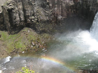
Rainbow Falls.

We were discussing going to Hot Creek to perhaps have a dip (although we were taking our chances because last time I had been there it was closed to swimming), when Rodney looked at our Devil’s Postpile map, and pointed to a label at the Reds Meadow Campground - “Showers.” Hmmm … we were walking in that direction to a bus stop so why not check it out? As we approached the campground, I was mentally calculating how much I would pay for a shower. Much to our delight, we read this:

And, so, we helped ourselves to these:

It was stunning. The water was perfect. I could barely tear myself away. But we eventually did leave the showers. We caught the bus back to Mammoth, which was crowded with smelly Pacific Crest Trail hikers. Over the past several days, I had wondered, looking up at the cloud-covered Sierra Nevada, how the PCT hikers were faring. The whole bus ride back over to the Eastside I heard tales of fog and getting lost. We then went to Hot Creek (which is still closed because of increased seismic activity) and it started to cloud up and eventually rain.

Hot Creek.
We treated ourselves to the gas station/Whoa Nellie Deli for dinner. There was a lot of steak on my salad, but I was hungry so I pretty much ate it all. This proved to be a major tactical error, which would continue to haunt me for the next few days.

Crater
Next day dawned the first normal Sierra Nevada Day. It started off cool and got hot by the end of the survey. We did the Crater Fire, which Rodney and I had surveyed last year.

Crater Fire with Mono Lake in the background.
It’s a lovely site that still had plenty of BBWO. Rodney also found a nest in this snag.

Listen to the nestlings. At about five seconds you can hear one of the parents drum on a nearby Jeffrey Pine.

Me in Crater.

Hetch Hetchy
We decided to stop by Hetch Hetchy on our way out to our last fire, Kibbie, which we also had surveyed last year. I had never been to one part of Hetch Hetchy, and we had just enough time to squeeze the hike in. This was another long drive, though. We had to go over Tioga Pass and then through Yosemite, out Big Oak Flat and then in to Hetch Hetchy. We hiked over O'Shaughnessy Dam and out to Wapama Falls, which were running heavy because of all the recent rain.

The dam.

The reservoir.

Wapama Falls.

Kibbie
We came back out and then drove to Kibbie. We got to the trailhead parking lot in time to eat and throw our tents down. The mosquitoes were bad, which was an ominous foreshadowing for the next day.

We got up and hiked about a half hour before we started our surveys. My route only overlapped last year’s by one point. And, I actually surveyed more than the usual ten points to make that happen. I had completed the ten and was almost out of time. We usually stop 3 ½ hours after sunrise, which works out to be around 9:15 a.m. I knew I was near my first point from last year, though, and that’s where I had a woodpecker. So I forged ahead and was rewarded with a pair. The mosquitoes were incredibly annoying all morning.

Here's a meadow that was full or mosquitoes, and birds, though not a Black-backed Woodpecker.
Because of a bad night’s sleep, I was exhausted that morning. On top if that all, I had a meat hangover. Good thing it was the last survey before another break. When we finished up, we drove back to Rodney’s house in the Bay area. He very generously offered to let me stay the night, so I did. The next morning I was dropped off at the rental car place and was off on my own adventure for two days, until I was to meet up with Bob at the Fresno airport to begin my last tour.